2018/19
Digitalising the planning system:
Masterplanner
At the end of 2018 I was involved in designing a master planning tool for urban designers in collaboration with KPF Architects, called Masterplanner, which uses new technology to deliver faster, more agile and future-proofed master plans.
A master plan is a long-term urban planning document that aims to guide how an area will grow and change, and how new designed developments could impact an area. It provides a conceptual layout of a place to help guide urban planning and architectural decisions and includes a vision on buildings, land use, housing, transportation and community amongst other things.
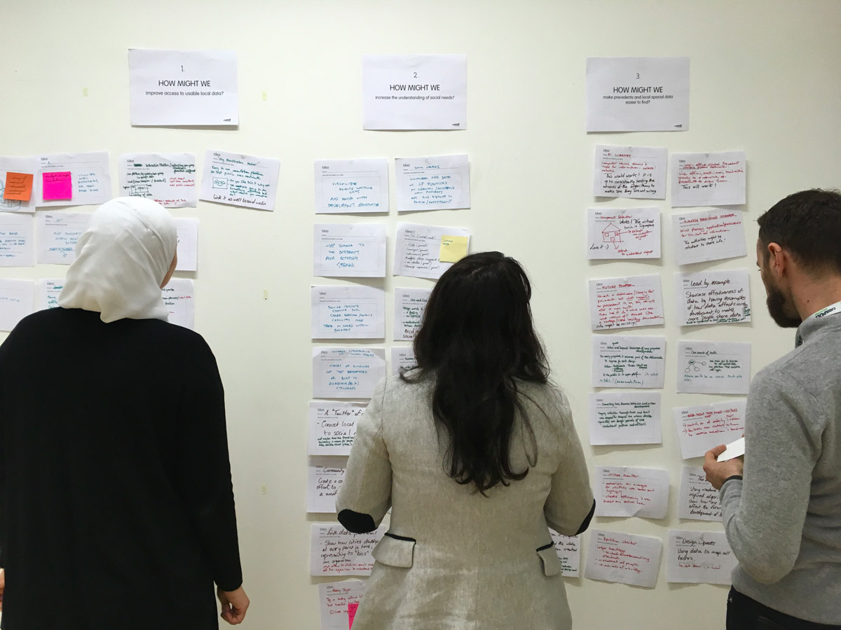
Through a design process that involved (amongst other activities) qualitative user research and ideation workshops, the typical user journey of an urban designer working on a masterplan for an area was uncovered. Painpoints were mapped onto the journey, that -once translated into design opportunities- were then addressed in a design for a concept of a new digital masterplanning application.
A master plan is a long-term urban planning document that aims to guide how an area will grow and change, and how new designed developments could impact an area. It provides a conceptual layout of a place to help guide urban planning and architectural decisions and includes a vision on buildings, land use, housing, transportation and community amongst other things.
Through a design process that involved (amongst other activities) qualitative user research and ideation workshops, the typical user journey of an urban designer working on a masterplan for an area was uncovered. Painpoints were mapped onto the journey, that -once translated into design opportunities- were then addressed in a design for a concept of a new digital masterplanning application.
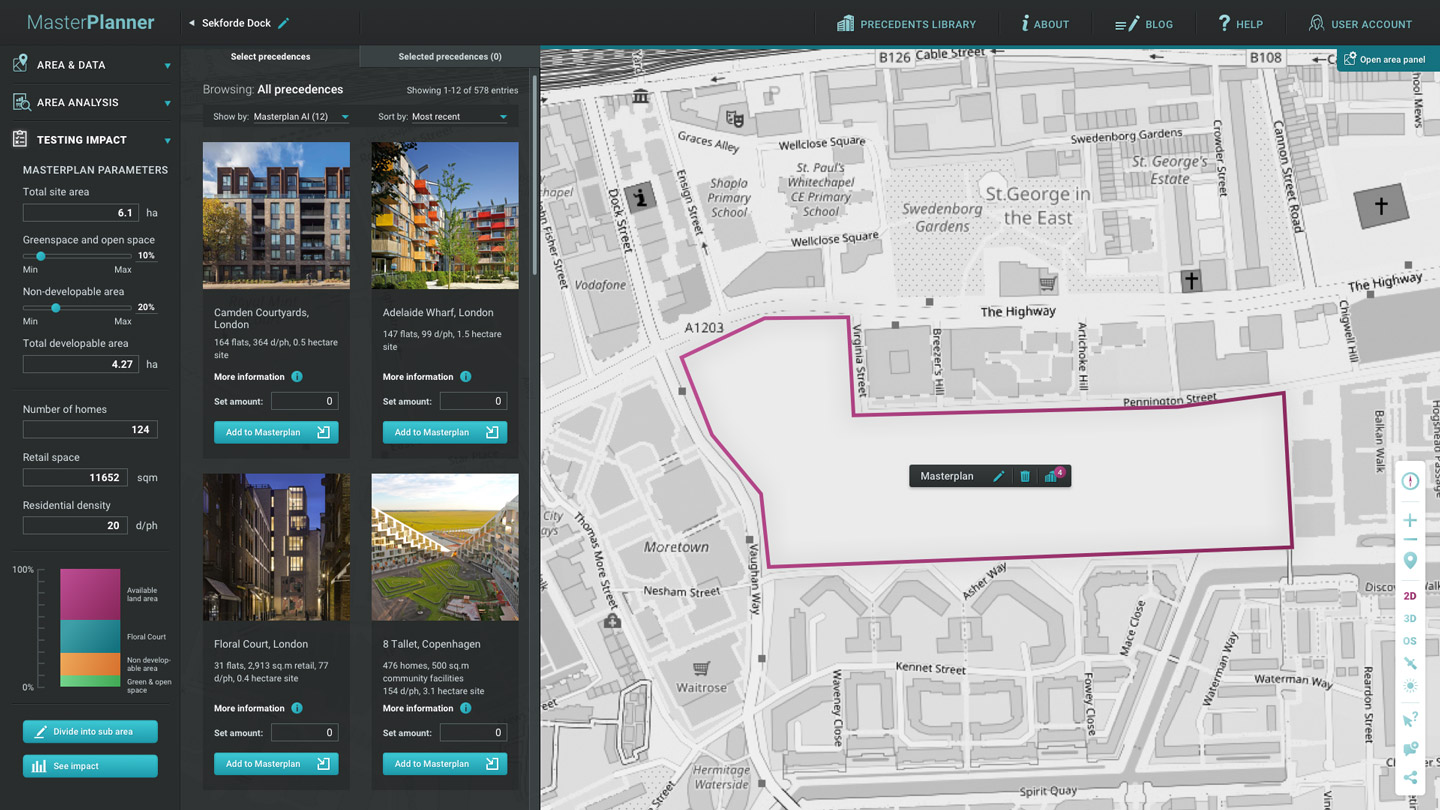
Masterplanner aggregates and combines data so that it can accompany planners along their respective current user journey(s) providing better insights into demographics, housing and transport needs, social infrastructure, and policy for an area. The use of the platform would enable urban designers to save a huge amount of time and effort.
It also has a precedent library that allows planners to test how different existing buildings and configurations would impact parts of their immediate surroundings and the area as a whole.
More information on the Masterplanning project can be found here, this project was featured in the London Festival of Architecture where Masterplanner was presented to the public.

The design problem
Urban designers or planners working on a masterplan for an area currently often encounter the following challenges:
Users of the product
Urban designers, city planners.
User research
Qualitative individual contextual interviews with 14 planners and urban designers, group session with 3 designers from the KPF Applied Research team in London.
Design process
This 6 week design sprint followed three main stages: user research, ideation and prototype design.
The user research was conducted without preconceived ideas and explored the whole journey of master planning and the pain points that are encountered throughout the process. Ideation focused on some of the pain points that emerged in the user research, and the design of the prototype addressed those that were considered most relevant and possible to solve through a new digital tool.
Urban designers or planners working on a masterplan for an area currently often encounter the following challenges:
- The data necessary to understand a site is hard to find. Often it is held by different organisations and not publicly available.
- Aggregating and combining different data sets is complicated as it is normally formatted in different ways.
- There is a potential to use (social) data to inform the designer that is currently often overlooked: social media, real-time movement and transport insights, etc.
- Spatial analyses and the testing of design options is time consuming and costly.
Users of the product
Urban designers, city planners.
User research
Qualitative individual contextual interviews with 14 planners and urban designers, group session with 3 designers from the KPF Applied Research team in London.
Design process
This 6 week design sprint followed three main stages: user research, ideation and prototype design.
The user research was conducted without preconceived ideas and explored the whole journey of master planning and the pain points that are encountered throughout the process. Ideation focused on some of the pain points that emerged in the user research, and the design of the prototype addressed those that were considered most relevant and possible to solve through a new digital tool.
Solution and results
A speculative and interactive digital prototype was developed that enables urban designers to easily visualise a range of different data sets that allow for a quick yet profound analysis of the urban tissue of an area. A library of precedents can be used to perform quick testing of design options.
Outcome and prototype was presented at the London Festival of Architecture 2019, the world’s largest annual architecture festival.
![]()
A speculative and interactive digital prototype was developed that enables urban designers to easily visualise a range of different data sets that allow for a quick yet profound analysis of the urban tissue of an area. A library of precedents can be used to perform quick testing of design options.
Outcome and prototype was presented at the London Festival of Architecture 2019, the world’s largest annual architecture festival.